
The Role of Advanced Technologies in Geosciences: GIS, Remote Sensing, Machine Learning, and Deep Learning
Mohamed AIT ABDELMALIK
11/20/20258 min lesen


Introduction to Geosciences and Advanced Technologies
Geosciences encompass a broad range of disciplines that study the Earth, its processes, and interactions within various systems. This field integrates aspects of geology, meteorology, oceanography, and environmental science, providing a comprehensive understanding of terrestrial phenomena. Scientists in geosciences aim to unravel complex relationships between natural elements and human activities, there by contributing to sustainable management and conservation efforts. As global challenges such as climate change, natural disasters, and resource depletion intensify, the importance of geosciences continues to grow.
In recent years, there has been a significant evolution in the methodologies employed in geosciences, primarily driven by the advent of advanced digital technologies. Techniques such as Geographic Information Systems (GIS), Remote Sensing, Machine Learning, and Deep Learning have revolutionized data collection and analysis in this field. These technologies not only enhance the accuracy of geospatial data but also facilitate the processing of vast datasets, which are crucial for understanding complex Earth systems. By leveraging these advanced tools, researchers can analyze information across spatial and temporal scales more effectively than ever before.
The reliance on these technologies ensures a more refined approach to the exploration of Earth’s processes. For example, GIS enables the visualization of geographic data spatially, while Remote Sensing allows for the examination of areas that are otherwise inaccessible. Meanwhile, Machine Learning algorithms can sift through massive datasets to identify patterns and make predictions regarding geological activities, thereby assisting in risk assessment and mitigation strategies.
As we proceed through this blog post, we will delve deeper into specific advancements within these areas and their integral roles in reshaping the landscape of geosciences.
Geographic Information Systems (GIS)
Geographic Information Systems (GIS) represent a vital technology in the field of geosciences, providing essential tools for capturing, managing, analyzing, and visualizing spatial data. Fundamentally, GIS integrates hardware, software, and data for spatial analysis, enabling scientists and researchers to comprehend complex geographic relationships and patterns. The significance of GIS in geosciences is underscored by its diverse applications, ranging from geological mapping to environmental monitoring and hazard assessment.
One of the primary functions of GIS is to facilitate the visualization of geospatial data through maps and 3D models. This capability allows researchers to identify spatial trends and relationships that may not be immediately apparent through numerical data alone. For instance, in geological mapping, GIS tools enable geoscientists to analyze various geological layers, providing insights into the composition and structure of the Earth’s crust. Moreover, GIS enhances the accuracy and efficiency of data collection, allowing for real-time updates and modifications as new information becomes available.
Another significant application of GIS in geosciences is hazard assessment. By analyzing spatial data, GIS can identify areas susceptible to natural disasters such as earthquakes, floods, or landslides. This information is crucial for emergency management and planning, ensuring that resources are allocated effectively to mitigate risks. Furthermore, GIS supports environmental monitoring by integrating various environmental data sources to assess pollution levels, ecosystem health, and land-use changes over time.
In conclusion, Geographic Information Systems are indispensable in advancing our understanding of geological phenomena. Their ability to manage and analyze spatial data, paired with visualization capabilities, significantly enhances the work of geoscientists. As technology continues to evolve, the role of GIS in geosciences will likely expand, further driving innovation and discovery within the field.
Remote Sensing in Geosciences
Remote sensing technologies have become a pivotal component in the field of geosciences, enabling scientists to capture and analyze data from a considerable distance. This is primarily achieved through the use of satellite and aerial imagery, which allows for the collection of vast amounts of information about the Earth's surface without the need for direct contact. The significance of remote sensing in environmental monitoring cannot be overstated, as it plays a crucial role in assessing changes in land use, tracking natural resources, and evaluating the impacts of climate change.
In geosciences, remote sensing provides a comprehensive view of geographical phenomena, facilitating the study of various environmental factors from a macro perspective. By employing a wide range of sensors and technologies, researchers can acquire data that informs land use planning and resource management. This capability is particularly important for understanding land degradation, urban development, and agricultural practices, where timely and accurate information is crucial for sustainable decision-making.
Among the diverse types of sensors used in remote sensing, optical, radar, and thermal sensors are frequently employed. Optical sensors capture visible and near-infrared light to monitor vegetation health, land use changes, and surface water bodies. Radar sensors, on the other hand, penetrate cloud cover and can operate during night hours; this makes them invaluable for monitoring topography and land movement. Thermal sensors detect heat emitted from the Earth’s surface, proving essential for studying temperature variations that influence ecosystems and climate.
The contributions of remote sensing to geological studies are substantial, particularly in mapping geological formations, assessing mineral deposits, and monitoring natural hazards such as earthquakes and volcanic eruptions. By integrating remote sensing data with geological models, scientists can enhance their understanding of the Earth's processes and make informed predictions about future developments. Overall, the integration of remote sensing technologies is instrumental in advancing the field of geosciences, providing essential tools for research and management.
Machine Learning Applications in Geosciences
Machine learning, a subset of artificial intelligence, has emerged as a revolutionary tool in the field of geosciences. By utilizing sophisticated algorithms, machine learning enables researchers and professionals to analyze vast and intricate datasets, thereby unveiling hidden patterns and trends that are not easily discernible through traditional methodologies. This capability is particularly vital in geosciences, where the nature of data can be complex and multi-dimensional.
One of the most significant applications of machine learning in geosciences is in mineral exploration. Algorithms can analyze geological data to identify potential mining sites, predicting where valuable resources may be located. This predictive modeling not only increases the efficiency of exploration but also reduces the costs associated with traditional geological surveys. The ability to process satellite imagery and other geological data through machine learning facilitates a more targeted approach, leading to improved resource management.
Another critical area where machine learning proves advantageous is in the predictive modeling of geological hazards such as earthquakes, landslides, and volcanic eruptions. By examining historical data and various geological factors, machine learning algorithms can forecast the likelihood of such hazards occurring in specific areas. This predictive capability enhances public safety and aids in disaster preparedness planning by providing timely and accurate information to decision-makers.
Additionally, machine learning is utilized for the automated classification of geological features. This application significantly streamlines the process of feature identification, leading to enhanced data accuracy. For instance, machine learning models can classify rock types, soil composition, and landforms based on training data, which not only saves time but also minimizes human error in geological mapping and analysis.
In essence, the integration of machine learning within the realm of geosciences fosters a data-driven decision-making framework. This advancement not only enhances the efficiency of research and exploration but also contributes to the broader goal of sustainable management of geological resources.
Deep Learning Techniques in Geoscience Research
Deep learning, a powerful subset of machine learning, has emerged as a vital tool in geoscience research, revolutionizing various aspects of data analysis and interpretation. Central to deep learning are artificial neural networks, which are designed to simulate the biological processes of the human brain. These networks consist of layers of interconnected nodes or neurons that are capable of learning complex patterns from vast datasets. In the context of geosciences, deep learning techniques are particularly effective for tasks such as image analysis, geological feature extraction, and seismic data interpretation.
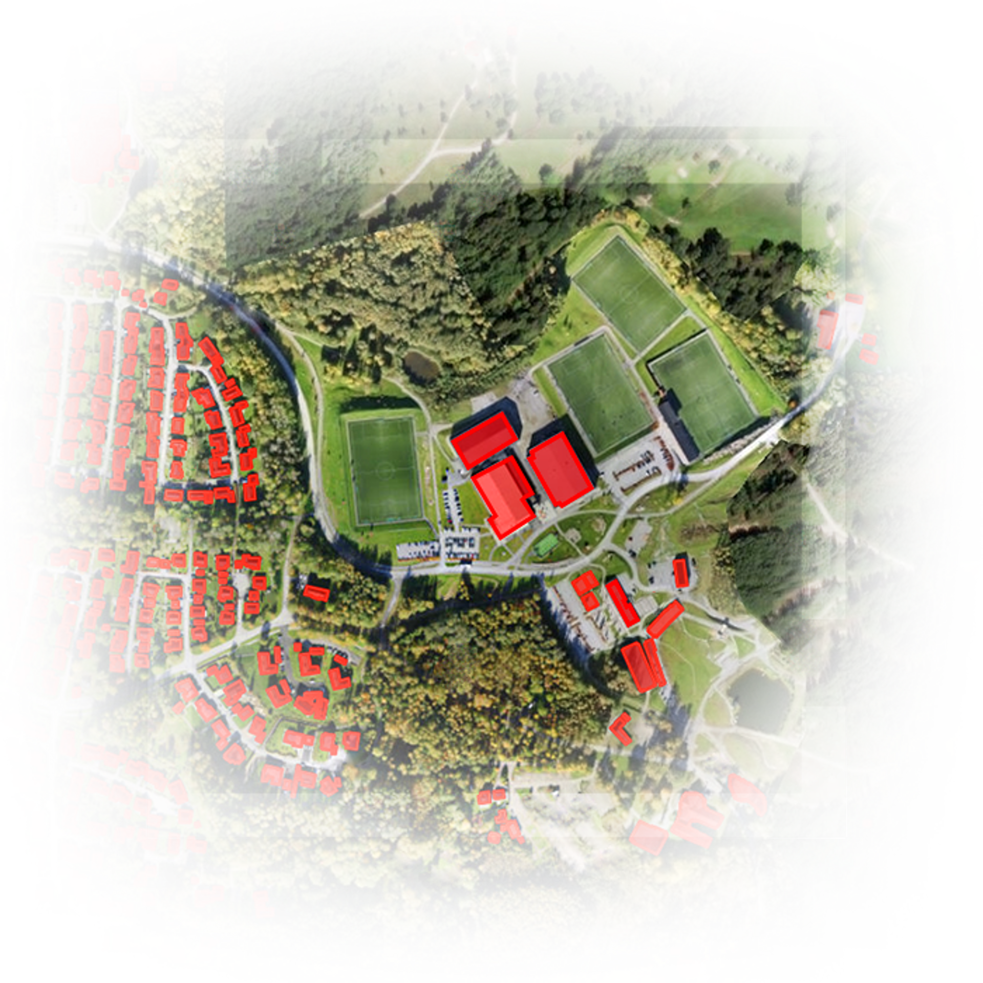
One of the key applications of deep learning is in the analysis of remote sensing images. By employing convolutional neural networks (CNNs), researchers can automatically detect and classify geological features such as faults, fractures, and mineral deposits from satellite imagery. These techniques enable geoscientists to generate more accurate maps and models, enhancing their understanding of the Earth's surface and subsurface characteristics.
Additionally, deep learning methods have shown significant promise in seismic data analysis. Traditional approaches often rely on manual interpretation, which can be both time-consuming and prone to human error. In contrast, deep learning algorithms can process large volumes of seismic data rapidly, leading to improved identification of subsurface structures and better estimations of resources, including oil and gas reserves. Notably, researchers have demonstrated success in using recurrent neural networks (RNNs) for time-series analysis, thereby advancing the field of seismic event detection.
Case studies exemplifying the effectiveness of deep learning in geosciences reveal its capacity to tackle complex challenges. For instance, a study utilizing deep learning architectures achieved remarkable accuracy in predicting landslide susceptibility, incorporating diverse datasets such as topography, vegetation, and climate data. These advancements highlight the transformative potential of deep learning techniques in enhancing predictive models and informing decision-making processes within geoscience disciplines.
Integration of Technologies for Enhanced Geological Insights
The integration of Geographic Information Systems (GIS), remote sensing, machine learning, and deep learning is transforming the field of geosciences by providing enhanced geological insights. These technologies, when employed collaboratively, facilitate sophisticated analytical processes that support the understanding of complex geological phenomena. GIS serves as a fundamental tool for spatial data management, allowing for the visualization and analysis of geological features in relation to their environment. By incorporating remote sensing techniques, geoscientists can gather extensive data across various scales, capturing large areas without the need for extensive fieldwork.
Machine learning algorithms play a pivotal role in analyzing the voluminous datasets generated from both GIS and remote sensing. The ability to identify patterns and make predictions based on historical data significantly enhances our understanding of geological processes. For instance, machine learning methods can classify landforms, predict mineral deposits, and assess geological hazards more efficiently than traditional approaches. Furthermore, deep learning techniques have begun to revolutionize image recognition tasks, particularly in interpreting satellite images or aerial photographs, revealing subtle geological features that may not be evident through conventional analysis.
The synergy among these technologies fosters interdisciplinary research, reducing the barriers between distinct geological fields and encouraging collaborative approaches. Such teamwork among geologists, data scientists, and remote sensing experts allows for a holistic perspective on environmental challenges. By leveraging the strengths of each technology, researchers can develop comprehensive models that consider various geological factors. Ultimately, this integrative approach not only enhances geological insights but also leads to more effective decision-making regarding resource management and environmental protection.
Future Trends and Challenges in Geosciences Technology
As we move forward into an era defined by rapid technological evolution, the geosciences sector stands on the cusp of embracing a myriad of advanced technologies including Geographic Information Systems (GIS), remote sensing, machine learning, and deep learning. These tools promise unprecedented efficiencies and capabilities in analyzing and interpreting geospatial data. However, alongside these advancements, several future trends and challenges must be recognized to ensure that technology enhances geoscientific research rather than hinder it.
One prominent trend is the continuous improvement of data processing capabilities. As geoscience applications generate enormous volumes of data, the demand for sophisticated algorithms and computing power to manage and analyze this data is paramount. Innovative machine learning techniques are being explored to streamline data handling, empowering researchers to extract meaningful insights more effectively and efficiently. However, this increase in complexity raises questions regarding data integrity and accuracy, necessitating robust frameworks for validation and verification.
Interdisciplinary collaboration is another vital aspect shaping the future of geosciences technology. The integration of expertise from diverse fields such as computer science, environmental science, and engineering is essential to tackle complex geoscientific problems. This collaboration not only fosters innovation but also drives the development of more holistic approaches to resource management and environmental protection. Nevertheless, creating effective partnerships across disciplines can be challenging, often requiring a paradigm shift in traditional collaborative methods.
Despite the promising outlook, geosciences technology faces substantial challenges. Issues related to data privacy and security are becoming increasingly critical as more sensitive information is gathered through these technologies. Additionally, technology accessibility remains a concern, particularly in less developed regions where resources may be limited. Finally, there is a pressing need for skilled professionals adept at leveraging these new technologies in geoscience, emphasizing the importance of education and training programs to prepare the workforce of the future. These intertwined challenges highlight the necessity for a balanced approach in pursuing advancements in geosciences technologies.